
AED Coverage Analysis
Client: Clarkson EMS/EH&S
Locate all AEDs on campus, estimate walk times to each device, and identify optimal locations for additional AED placement to improve coverage.
In Case of Emergency, Dial 911.
Clarkson CSS & CUEMS can be reached at (315) 268-6666
Background
Early defibrillation is a crucial link in the cardiac arrest chain of survival, yet Automatic External Defibrillation (AEDs) placement on many college campuses is based on meeting state minimums rather than well-thought-out, comprehensive coverage. This project, completed in collaboration with Clarkson University EMS, EH&S, and Safety and Security, focused on analyzing the placement of current AED stations, identifying coverage gaps and opportunities for growth using real-world call data and retrieval time modeling.
The Campus
Clarkson University sits on a 680-acre campus consisting of a mix of traditional academic buildings, residence halls, apartments, athletic fields, industrial and facilities plants, and specialized research labs. Unique to the Clarkson campus is the Clarkson Woods, a 400+ acre sprawling research and recreational forest comprising walking and biking trails, lookouts, Adirondack style lean-to structures, and a boathouse and riverside trail.
Clarkson has an “organic” layout with a large central spine of academic buildings surrounded by residence halls and recreational facilities. With no central quadrangle, pedestrians must cross underneath skybridges or through academic buildings to efficiently transfer from one part of campus to another without walking along the outer ring roads.

As-Built Map Generation
AED locations were recorded with ArcGIS Field Maps to create a GIS resource layer. Each point collected is tagged with a location name, AED Model, collocated items such as Naloxone (Narcan™), or a Stop the Bleed™ kit, and a photo of the AED including any wayfinding artifacts such as hallway signs or doors near the AED.
Due to the simplified user interface offered by Field Maps, CUEMS volunteers were able to be utilized to digitize the campus AED locations into an ArcGIS shapefile for further processing.


Existing AED Positions
The Collins Hill campus has 13 AEDs as a part of its Public Access Defibrillation (PAD) program. These AEDs are located primarily in academic buildings, food service areas, and gyms as required by NYS Public Health Law Section 3000-D. While the campus was technically in compliance with the law, the code is a floor not a ceiling when it comes to safety device placement. Reducing the time from recognition of a SCA to the activation of an AED is directly correlated with patient outcomes.
In addition to the required locations, Clarkson Safety and Security and CUEMS vehicles carry an AED and responding personnel are trained in Basic Life Support. Even though responders bring their own AEDs, it is important to know where a backup AED is if additional pads or collocated bleeding control supplies are required.

Network Dataset Generation
A network dataset is a special model within ArcGIS that is used to model transportation networks, typically including streets, paths, and intersections. The default models provided by Esri are for general use and include public roads across the United States. Since the goal of this project was to model walk-time between locations on campus, a custom network dataset needed to be created. The Clarkson network dataset includes sidewalks, parking lots, desire paths (unintended paths caused by foot traffic over vegetation) and sports fields to get an accurate picture of pedestrian movement on campus.
Note that some fields have X shapes drawn through them. Since in real life you can cross a field at any point, not just at the perimeter, the X shape reflects the shortened walk time across the field. The network dataset also includes a blanket impedance value of 30 seconds when crossing into or out of a building to account for the increased complexity of navigating inside a building and retrieving an AED.

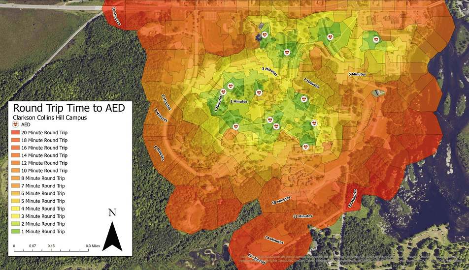
As-Built Round Trip Time to AED
The colors on this diagram represent the round-trip time to an AED. If you’re standing in the green, its likely a 1–2-minute round trip to get an AED and get back to a patient (assuming a light jogging pace of 4-4.5 mph). As you move deeper into the red, it takes significantly longer to reach an AED (up to 20 minutes round trip from some athletic fields). Comparing this to CUEMS call location data from the past three years, approx. 15% of high-acuity calls occurred further than a 10-minute walk from an AED.
Based on the walk time chart, the round-trip time was stratified into three classes of 1- 3- and >3-minute round trip walk time to an AED. These times were selected using the current AHA BLS recommendations for defibrillation. 80% of Clarkson’s athletic fields are further than 3 minutes from an AED. While Athletic Trainers bring AEDs to D1 and D3 games, many club games and practices do not have an AED on site if CUEMS is not present. Furthermore, all of Clarkson’s apartment-style housing and Greek Life Housing is further than 3 minutes from an AED under the best conditions, with snow and ice during the winter months causing even more delay.

Proposed Stations
Using EMS Call Data, population density, and distance from existing AEDs, six candidate sites were identified for AED installation. At an indoor installation cost of $1,776 and an outdoor installation cost of $2,226, all six sites can be equipped with an AED for just $12,000. With the six proposed stations, 18% (+8%) of the campus is within one minute of an AED and 51% (+23%) is within three minutes of an AED.


Data Integrations
The data from this project was added as a resource layer in ActiveAlert, the dispatch and emergency response coordination platform used by Clarkson. Responders can see the nearest AED to a scene on the dispatch page. Additionally, the data has been added to the National Emergency AED + Resource (NEAR) Registry. This means that anyone with the NEAR Registry mobile app has immediate information about the closest AED to them in an emergency, even before professional responders arrive on scene.


